Ariel Vallis
GIS Technician
Shag Harbour NS Field Survey Results
This map was produced for the NSCC Applied Geomatics Research Group using ArcGIS 10.3.1 for desktop. The purpose of this map is to display and interpret percentage values of submerged vegetation (eelgrass) observed during a ground truth survey completed at Shag Harbour, Nova Scotia, by the AGRG in 2015. Additionally, the task was to use GIS to spatially link underwater GoPro images captured during the survey to their corresponding GPS points. This allows the map reader to visually interpret the distribution of eelgrass within the study area.
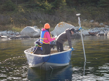
Data were acquired in the field by myself as well as two AGRG researchers using a Leica GS14 system. 2 GoPro cameras were manually deployed, coinciding with each GPS point captured during the survey. Time, weather, tide and other in-situ notes were recorded throughout the survey. Once GPS data were acquired, processed and stored in a readable GIS file, the file was imported into Microsoft Excel as a DBF (database file).
Excel was used to spatially link photos to their respective points. A new field was added to the Excel table to contain a coded string for each GPS point. This coded string was used to link each spatial point to its underwater photo via the photo’s folder directory. The Excel file was imported into ArcMap and exported as a new shape file. Using the ArcGIS HTML pop up extension, it became possible to click on a GPS point and have the photo and corresponding attributes pop up. Fields were also added to this shape file to store eelgrass percentage values and water clarity observed at the time of the survey. Percentage values were derived from the official SeagrassNet (Global Seagrass Monitoring Network) Monitoring Manual.
For a PDF of this map, or any additional questions about this project, please contact me directly at arielvallis@gmail.com.

